Where is Hunza Located? A Hidden Himalayan Paradise Unveiled
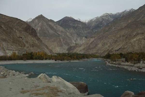
I still remember the first time I laid eyes on Hunza Valley — not in person, but through a photo shared by a traveler on social media. The image was surreal: snow-draped peaks, a crystal-clear turquoise river, and terraced fields glowing in the autumn sun. As someone raised in the bustling city of Lahore, the scene looked like something from another world, a mystical postcard far beyond reach. But once I finally made the journey there, I realized something important: Hunza is real — and it’s waiting for everyone to discover.
But here’s the twist: many people ask me the same question — “Where exactly is Hunza located?” Even seasoned travelers often confuse it with other northern destinations in Pakistan. So in this blog post, we’ll explore the geography, accessibility, and key locations within Hunza, breaking it down so clearly that you’ll not only understand where it is — you’ll want to start packing your bags.
Table of Contents
So, Where Exactly Is Hunza?
Hunza is located in the Gilgit-Baltistan region of northern Pakistan. Geographically, it lies within the extreme northern territories, nestled amidst some of the world’s tallest mountains — the Karakoram Range. It’s approximately:
600 km from Islamabad
320 km from Gilgit city
80 km from the Khunjerab Pass, the highest paved international border crossing in the world (linking Pakistan with China)
Coordinates of Hunza:
Latitude: 36.3167° N
Longitude: 74.6500° E
If you look at a map, Hunza Valley is strategically positioned along the Karakoram Highway (KKH) — the world-famous road that connects Pakistan with China and was historically part of the ancient Silk Route. Understanding the Regions Within Hunza
Hunza is not just a single town or village — it’s a district made up of three main subdivisions:
1. Upper Hunza (Gojal)
Includes places like Gulmit, Passu, Sost, Misgar, and Khunjerab Pass
Known for its glaciers, high-altitude lakes, and proximity to the Chinese border
2. Central Hunza
Main commercial and tourist area
Includes Karimabad, Altit, Baltit Fort, Aliabad, and Duikar
This is where you’ll find most hotels, cafes, and historical forts
3. Lower Hunza
Includes towns like Nasirabad, Murtazaabad, and Hussainabad
Serves as the entry point when coming from Gilgit
Each subdivision offers its own unique blend of culture, natural beauty, and heritage. When people refer to “Hunza,” they usually mean Central Hunza, but it’s worth exploring all three regions for a complete experience.
How Do You Reach Hunza?
Although remote, Hunza is very accessible, especially with improvements to the Karakoram Highway. Here’s how you can get there:
By Road:
From Islamabad:
Distance: ~600 km
Travel Time: 15–18 hours
You’ll pass through cities like Abbottabad, Mansehra, Besham, Dasu, Chilas, and Gilgit before entering Hunza.From Gilgit:
Distance: ~100 km
Travel Time: 2.5–3 hours
Regular local transport, private cars, and tourist vans are available.
By Air:
Fly to Gilgit Airport from Islamabad (1-hour flight)
Then continue by road to Hunza (2.5–3 hours drive)
Pro Tip: Book early morning flights since weather conditions can cancel later departures.
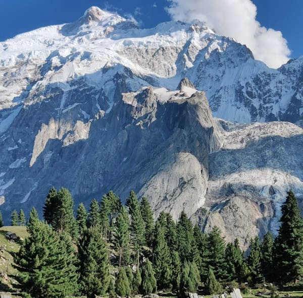
Geography and Elevation
Hunza sits at an altitude of approximately 2,438 meters (7,999 feet) above sea level. This high elevation results in:
A cooler climate, even in summer
Crisp, clean air
Some of the most dramatic landscapes in Asia
The valley is surrounded by famous peaks like:
Rakaposhi (7,788 m)
Ultar Sar (7,388 m)
Ladyfinger Peak
Diran Peak
This is not just geography — it’s visual poetry.
A Glimpse into Hunza’s Historical Significance
Hunza has long served as a key strategic and cultural corridor between South Asia, Central Asia, and China. It was once a princely state that maintained autonomy until it officially acceded to Pakistan in 1974. Its location made it an essential part of the ancient Silk Route, with traders passing through to China and beyond.
You can still visit remnants of this rich past, such as:
Baltit Fort – Over 700 years old
Altit Fort – Restored by the Aga Khan Trust
Silk Route Gallery in Gulmit – Dedicated to preserving history
Nearby Attractions That Define Hunza’s Location
Here’s why the valley’s location makes it a hub for explorers:
Attabad Lake
Formed by a landslide in 2010, this stunning turquoise lake is en route to Upper Hunza.
Khunjerab Pass
The world’s highest border crossing at 4,693 meters — accessible from Gojal (Upper Hunza).
Passu Cones
Located in Gojal, these cathedral-like peaks are among the most photographed in Pakistan.
Husseini Suspension Bridge
One of the most dangerous-looking bridges in the world — and right in Hunza!
Culture, Language, and People
Hunza’s location has influenced its cultural diversity. It is home to various ethnic groups, including:
Burusho (Burushaski speakers)
Wakhi (Wakhi language)
Shina speakers in nearby areas
This diversity in such a remote location is a testament to centuries of trade, migration, and isolation from external conquest. The valley is also known for its progressive attitude toward education and women’s empowerment, thanks to sustained community development.
What You Should Pack (Due to the Location)
Hunza’s location in the high mountains means you should pack accordingly:
Essentials:
Warm clothing (even in summer evenings)
Sunscreen and sunglasses
Trekking shoes
Reusable water bottles
Emergency medicine (especially for altitude sickness)
Tip: Weather changes quickly due to high altitude — always carry layers.
Why Its Location Matters
Hunza’s location isn’t just a geographical point — it defines the valley’s:
Strategic importance (Silk Road, trade with China)
Cultural blend (influence from Central and South Asia)
Unique biodiversity and climate
Tourism potential as a safe and welcoming northern destination
Its isolation historically helped preserve its culture, language, and health systems. Ironically, now it’s the remoteness that draws in travelers from around the world.
What This Location Taught Me
As someone who has now visited Hunza multiple times, I can say with certainty that its location changes you. You begin to value simplicity, silence, and the kind of human warmth that comes from communities shaped by nature — not concrete. Whether I was hiking through Passu Glacier or sharing apricot soup with a local family in Gulmit, the location wasn’t just a backdrop — it was the soul of the experience.
Now that you know exactly where Hunza is located, what’s stopping you from visiting? Whether you’re a photographer, trekker, or simply a soul looking for stillness — Hunza is the destination you didn’t know you needed.
Pack your bags. Print your map. And prepare your heart — because Hunza will claim it.
The Takeaway
Traveling in Pakistan is both exciting and accessible because to its varied transportation system. Every type of traveler has an alternative, from the convenience of ride-hailing services to the affordability of buses and trains.
Metro busses, Careem, and Uber are the most convenient means of transportation for brief city excursions. Pakistan’s picturesque train routes and opulent bus services offer comfortable and reasonably priced long-distance travel. The quickest option to travel long distances is still by domestic flight, particularly when traveling to far-flung northern locations.
Are you prepared to travel to Pakistan? Plan your vacation now to take advantage of the amazing nation’s transportation infrastructure!
Explore carefully planned tours to see the best of this fascinating nation. Please get in touch if you would need more travel advice; we are happy to assist you in organizing your upcoming journey! Additionally, by completing this form, you can personalize your journey.
FAQs – Everything You Need to Know
1. Is Hunza part of Pakistan or China?
Hunza is in Pakistan, within the Gilgit-Baltistan region, and has no territorial overlap with China.
2. Is Hunza located near the Himalayas?
Hunza lies within the Karakoram Range, which is geologically distinct from the Himalayas but equally impressive.
3. How far is Hunza from Islamabad?
Approximately 600 km by road; it takes around 15–18 hours depending on route and traffic.
4. Can I see China from Hunza?
Yes! From Khunjerab Pass, which is in Upper Hunza, you can cross into China’s Xinjiang region.
5. Is Hunza accessible in winter?
Yes, but Upper Hunza (like Khunjerab) may be closed due to snow. Roads to Central Hunza usually remain open.
6. What is the altitude of Hunza?
About 2,438 meters (8,000 feet) above sea level.
7. Is Hunza safe for tourists?
Yes! It’s one of the safest and most tourist-friendly regions in Pakistan.
8. Do I need a permit to visit Hunza?
Pakistani citizens do not. Foreigners may need a No Objection Certificate (NOC) for areas near the border.
9. Which language is spoken in Hunza?
Mainly Burushaski and Wakhi, though most people also understand Urdu and some English.
10. Is Hunza a valley or a town?
It’s a valley and a district, containing multiple towns and villages.
11. Can I use Google Maps in Hunza?
Yes, though download offline maps in advance as internet connectivity can be spotty.

Daniel loves exploring off-the-beaten path destinations and making new friends. Writing blog posts since 2015, Daniel says it helps him to document his travels and cherish them. He loves the fact that what he writes might actually help someone have a better experience in Pakistan and Afghanistan. In his spare time, he loves listening to Tchaikovsky and spend time with his dog Coconut.
Our Most Popular Trips


